
Conconully Safety of Dams Modification Project Draft Environmental Assessment
Project Background

Photo credit: Bureau of Reclamation
Project Overview
The Bureau of Reclamation prepared a draft EA for the Conconully Safety of Dams Modification project. The project area is located in Okanogan County, 17 miles north of Omak in north-central Washington. While Conconully Dam is performing as designed, investigations conducted under Reclamation’s Safety of Dams program determined that the dam is potentially at risk of seismic failure associated with liquefaction of embankment and foundation materials. Liquefaction occurs when loosely packed, water-logged sediments at or near the ground surface lose their strength in response to strong ground shaking. This risk could result in dam failure, which poses unacceptable risk levels to people, property, and the environment. This project is authorized under the Safety of Dams Act (Public Law 95-578).
Purpose and Need
The purpose of the proposed project is to improve public safety by reducing risk associated with liquefaction of embankment and foundation materials, maintain water deliveries and flows for irrigators and endangered species, and continue to provide recreational benefits and fish and wildlife habitat.
The need for the proposed project is to comply with Reclamation's Safety of Dams’ requirements and reduce static, seismic, and hydrologic risks at Conconully Dam to acceptable levels based on Public Protection Guidelines, improve control of water flows through the outlet works, and increase the reliability and longevity of the dam and water conveyance system.
Background
The project area contains Conconully Dam, which is owned by Reclamation and operated by the Okanogan Irrigation District. Conconully Dam and Reservoir are located on Salmon Creek, approximately 17 miles north of Omak, Washington. As a component of the Okanogan Project, the reservoir provides irrigation water to downstream irrigators and recreation opportunities out of the town of Conconully north of the dam. Conconully Reservoir has a storage capacity of approximately 13,000 acre-feet and a reservoir water surface area of 450 acres at full pool.
Conconully Dam was constructed using hydraulic fill methods between 1907 and 1910 at the confluence of the north and west forks of Salmon Creek. The hydraulic fill construction technique used during the construction of the dam consisted of selectively placing soil or other materials using a stream of water to move embankment materials through flumes to the dam site. The resulting puddled-core embankment is currently known to be susceptible to liquefaction and increased risk of failure in the event of seismic activity.
Hydraulic mining of dam fill materials
Photo credit: Bureau of Reclamation

Hydraulic fill construction and puddled core
Photo credit: Bureau of Reclamation

Hydraulic fill construction method
Photo credit: Bureau of Reclamation

Hydraulic fill construction method
Photo credit: Bureau of Reclamation

Material transport via a flume to the dam site
Photo credit: Bureau of Reclamation
Evaluations of the risk of seismic failure associated with liquefaction of the dam’s embankment and foundation materials began in the 1990s. The geotechnical and risk analyses indicated that existing risks were at an unacceptable level based on Reclamation’s Public Protection Guidelines and justified additional work to better define or understand the risks. Subsequent geotechnical evaluations, field explorations, and risk analyses demonstrated that the embankment requires modifications to reduce the seismic risks to the dam.
Reclamation completed a corrective action study to evaluate alternatives that would reduce seismic risks to Conconully Dam. The corrective action study developed two structural modification alternatives, a reservoir restriction alternative, and a dam breach alternative; the corrective action study also evaluated a no action alternative. The two structural modification alternatives included an excavate and replace alternative and a deep soil mixing alternative. The excavate and replace alternative proposed to excavate and replace foundation materials susceptible to liquefaction. The deep soil mixing alternative proposed the use of deep soil mixing reinforcement columns to improve foundation materials. Both structural modification alternatives would construct a stability berm on the specified foundation type on the downstream face of the dam.
After evaluating the corrective action study alternatives, Reclamation selected the deep soil mixing alternative as the corrective action to be evaluated in the draft EA.
Reclamation analyzed two action alternatives as discussed below.
Alternative B—Proposed Action
Reclamation proposes to reduce the risk of dam failure due to seismic activity by constructing a stability berm on the downstream face of Conconully Dam. The stability berm would be built on a foundation of deep soil mixing reinforcement columns to improve the strength and resilience of the dam’s foundation materials. Reclamation also proposes to upgrade and extend the outlet works in an east alignment to ensure compatibility with the proposed stability berm. Additionally, new water control systems and facilities would be installed to enhance operational functionality. Lastly, a boat ramp would be constructed to launch the barges for spillway pumping and intake bulkhead placement. Activities would primarily occur downstream of the dam (dry or stream side), with limited activities upstream of the dam (wet or reservoir side).
Alternative B Overview Map—Proposed Action

Alternative B Disturbance Area
Alternative B would result in 18.7 acres of permanent disturbance, which consist of areas that would occur for 10 years or longer and would not be restored to pre-construction conditions. Permanent disturbance typically represents facility footprints, such as the constructed dam access road, boat ramp, stability berm and outlet works.
There also would be 41.7 acres of short-term disturbance, which consist of areas that would undergo impacts for up to 10 years post-construction and ultimately would be restored to pre-construction conditions. Short-term disturbance would include areas like portions of the borrow area that would undergo surface disturbance and revegetation.

Stability Berm and Deep Soil Mixing Column Foundation
The proposed stability berm would be constructed on a foundation of reinforced deep soil mixing reinforcement columns on the downstream side of the existing dam embankment. The underground DSM columns would be installed individually in an overlapping pattern to create a foundation for the stability berm that would not be subject to liquefaction and would have a very low probability of strength loss due to seismic activity. Deep soil mixing is a ground improvement technique that augments the characteristics of weak soils by mechanically mixing them with a binder to a target depth. The proposed rows of soil-cement, referred to as soilcrete, overlapping columns increase the soil’s strength and rigidity. This creates a foundation that improves the structural integrity of the embankment which reduces the risk of seismically induced dam failure and meets Public Protection Guidelines.

Deep soil mixing technique
Photo credit: Bureau of Reclamation

Deep soil mixing testing at Conconully Dam
Photo credit: Bureau of Reclamation
Construction of the stability berm would start after installation of the deep soil mixing columns. The stability berm would be constructed on the DSM foundation with zones of sand and gravel to provide internal filtration, capture, and drainage of water from the dam and berm. The remainder of the stability berm would be composed of miscellaneous compacted backfill obtained from the borrow area or commercial sources. The stability berm would be reinforced with gravels, cobbles, and boulders obtained from the borrow area for slope protection and erosion control. When completed, the crest elevation of the stability berm will be approximately 1 foot higher than the top of the current dam embankment (Figure 1).

Figure 1: Alternative B deep soil mixing foundation treatment and stability berm.

Figure 2: 3D simulation of the proposed Conconully Dam stability berm.

Example of stability berm at Boca Dam on the Little Truckee River, California.
Photo credit: Bureau of Reclamation.
The stability berm would conform with the outlet works – east alignment, shown below.

Outlet Works and Valve House
To provide improved operational functionality and compatibility with the proposed stability berm, Reclamation also proposes to upgrade the outlet works by extending, lining, and reinforcing water conveyance components and installing contemporary water control systems and facilities (Figure 2). A new reinforced concrete building (i.e., valve house) near the toe of the stability berm would accommodate multiple state-of-the-art valves to facilitate a range of water discharges for specific purposes—emergency reservoir, irrigation, base flow, and low reservoir elevation releases. Under Alternative B, the outlet works would discharge to two separate locations.

Figure 3: Alternative B outlet works plan and section view.
For additional details on the construction, modification, or installation of other dam components, including the intake bulkhead, stilling basin, discharge channel, valve house, gate house, control house, stability berm, toe drain, relief wells, spillway pumps, borrow area, boat ramp, access roads, administrative/storage/staging area, security infrastructure and utilities, see the draft EA.
Alternative C
Under Alternative C, Reclamation would upgrade the strength and resilience of Conconully Dam as described under Alternative B, but with a few component construction and location differences. The key differences in the components under Alternative C when compared with Alternative B would be the shorter stability berm, the corresponding west alignment of the outlet works, and locations of the toe drain, stilling basin, and valve house. Under Alternative C, a boat ramp would not be built. Instead, any barges needed for installing the intake bulkhead or the spillway pumps would be lowered into the reservoir using a crane or launched from the existing boat ramp at Conconully State Park, if feasible.
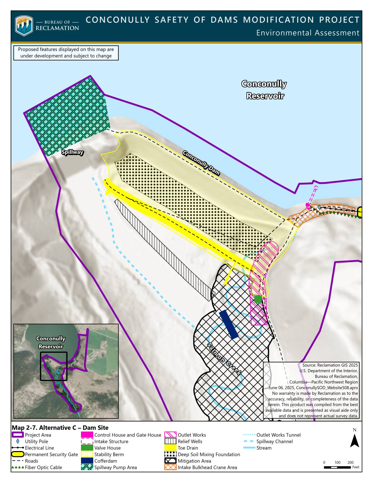

Figure 4: Alternative C deep soil mixing foundation treatment and stability berm.

Figure 5: Alternative C outlet works plan and section view.
Alternative C Overview Map

Alternative C Disturbance Area
Alternative C would result in 17.9 acres of permanent disturbance, which consist of areas that would occur for 10 years or longer and would not be restored to pre-construction conditions. Permanent disturbance typically represents facility footprints, such as the constructed dam access road, boat ramp, stability berm and outlet works.
There also would be 42.2 acres of short-term disturbance, which consist of areas that would undergo impacts for up to 10 years post-construction and ultimately would be restored to pre-construction conditions. Short-term disturbance would include areas like portions of the borrow area that would undergo surface disturbance and revegetation.

For more information on the Conconully Safety of Dams Modification project EA, please visit the project website or contact Jason Sutter, Bureau of Reclamation NEPA lead at bor-sha-consod@usbr.gov.
To be added or removed from the mailing list, please contact Val Stanson at val.stanson@aecom.com.
Individuals who are deaf, blind, hard of hearing, or have a speech disability may dial 711 (TTY, TDD, or TeleBraille) to access telecommunications relay services.