Scoggins Dam Safety Modifications Project Environmental Impact Statement
Frequently Asked Questions

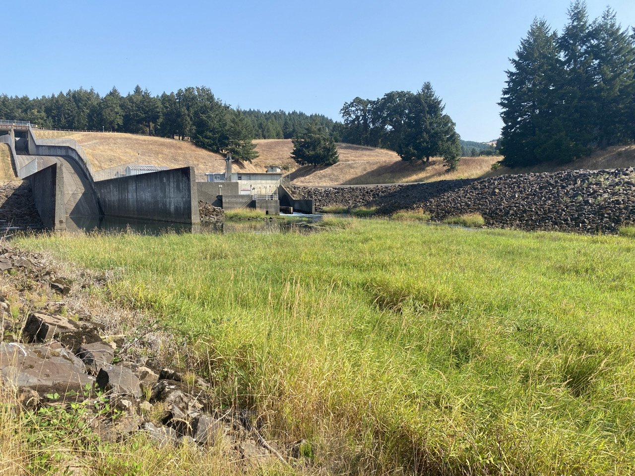
Photo credit: Bureau of Reclamation
Frequently Asked Questions
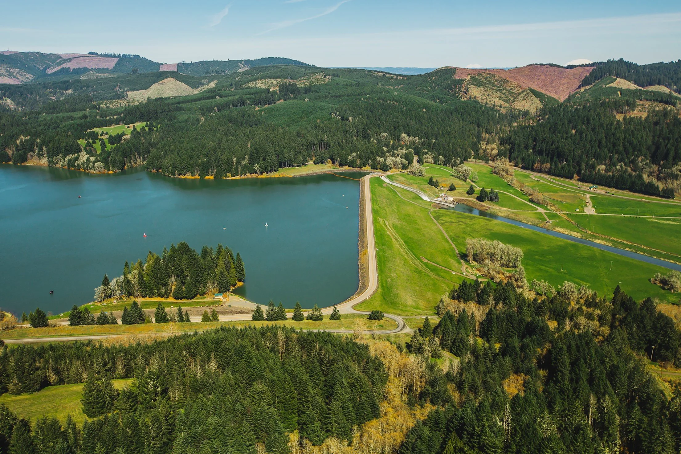
Aerial view of Scoggins Dam.
Scoggins Dam Details
Who owns and operates Scoggins Dam?
The Bureau of Reclamation owns Scoggins Dam, and the Tualatin Valley Irrigation District operates the facility.
When was the dam built?
Original construction of the earth-fill dam began in 1972, was completed in 1975, and utilized engineering techniques appropriate for that timeframe.
What is an earth-fill dam?
An earth-fill dam (also known as an earthen dam) uses materials obtained from earth and rock from borrow areas located near the dam site.
Why wasn’t the dam originally designed for earthquakes?
Little was known at the time about the potential faults in the area. Research conducted since the 1970s has greatly increased dam-design knowledge associated with potential impacts from earthquakes.
Dam Safety
Why is it necessary to modify the dam?
Scoggins Dam is sound and is performing as designed. Reclamation’s Safety of Dams program is focused on ensuring long-term stability of dams to protect lives and property. Reclamation is considering a dam modification to address risks and safety concerns associated with a large seismic event.
What is Reclamation doing now to improve dam safety?
The dam is operating in a safe condition and its performance is routinely monitored and inspected.
Why does this process take so long?
The process to verify the need for dam modifications is very extensive. Reclamation follows a rigorous process of investigation and evaluation to provide high confidence in our analysis and to ensure that Reclamation designs and constructs the most appropriate modifications for a dam.
Does the state of Oregon have earthquakes?
Scoggins Dam lies within the Gales Creek fault zone. The Cascadia Subduction Zone off the Pacific Coast shoreline is also a source of seismic concern in Oregon.
How will earthquake warnings be issued?
Warnings are issued and handled through the Washington County Emergency Management office. They have various means of communication, ranging from text alerts to notification from emergency responders.
Should I leave my house if an earthquake occurs?
If you are below a dam, protect yourself—know your flood zones and evacuation routes. In the event of an earthquake, do not wait, take action. Warnings are issued and handled through the Washington County Emergency Management office. Follow all directions and information from their office.
Construction
What is the schedule for the construction and when would it be begin?
Reclamation is moving forward with design development and anticipates making a decision from the alternatives analyzed in the EIS by 2025. Depending on the selected alternative, final design could end as early as 2027, with onsite construction beginning in 2029.
How long will construction take?
Reclamation estimates the onsite construction will last approximately six years. The length of time for construction may vary, depending on the final design of the project.
What type of work is being considered for the dam?
Excavate and backfill portions of the crest and existing embankment.
Construct a downstream shear key.
Install a downstream rock filter and drain.
Install a stability berm over the shear key and downstream slope of dam.
Raise the dam crest.
Demolish the existing spillway, bridge, and ancillary features.
Construct a new spillway, bridge, and ancillary features and extend outlet works.
Construct a new two-lane road across the dam.
Costs
What is the cost of the project?
We are in the pre-design and environmental compliance phase and will transition to final design in 2027, pending outcome of the environmental review. The cost of modifying the dam is roughly between $600 million and $1.5 billion. The range of cost is based on potential final design features that may be impacted by future costs of materials, fuel, and labor.
Who is paying for this work?
Under the Safety of Dams Act, project costs are shared among the Bureau of Reclamation and the beneficiaries (such as, irrigation water users, municipal water users). Reclamation will pay 85 percent of the project costs, while the beneficiaries split the remaining 15 percent.
Resource Impacts
What are the anticipated environmental impacts from the project?
Impacts on resources such as recreation, surface water, wildlife, visual resources, or noise levels are yet to be determined. Details of the exact work and anticipated impacts will be analyzed within the EIS. Reclamation will make every effort to ensure there is clear and open communication with the public throughout the planning process.
Will private property need to be accessed?
Reclamation anticipates only accessing federal, or publicly accessible lands, such as Henry Hagg Park.
Will the field work result in any disturbances to soil, vegetation, or structures?
Reclamation expects little to no disturbance to the resources it is collecting data on. During the wetland delineation survey, soil samples may be taken to estimate water content because the wetland is mapped. Flagging or markers may be left in place to indicate protected areas. For noise sampling, Reclamation personnel will collect ambient noise data, requiring the use of non-permanent and portable equipment for 10 to 12 hours. The equipment would be removed after the information is collected. During cultural resource surveys, up to 40 shovel test probes may be conducted at the direction of field director, approximately 35 centimeters in diameter, up to 1 meter deep.
NEPA Process
Why is Reclamation doing NEPA?
This project is proposed by Reclamation on federal lands, will use federal funding, and will require federal permits; therefore, NEPA is required for this federal actions. Further, Reclamation is seeking to secure funding authorization through the Office of Management and Budget, which requires a NEPA analysis to review Reclamation’s funding request.
What will be included in the development of the EIS?
The EIS will include an analysis of the potential environmental effects of the proposed action, a no-action alternative, and a reasonable range of alternatives designed to respond to the project’s purpose and need.
What is the proposed federal action?
Reclamation is proposing structural modifications to Scoggins Dam to reduce public safety risk in the event of a severe seismic event. Proposed improvements to loadings response performance of the facility include raising the dam crest, constructing a downstream shear key, creating a new spillway, and placing additional berm material over the existing dam. Improvements and modifications to the dam will effectively reduce the safety risks it poses for the downstream public.
What is the public process for the EIS?
Reclamation will provide notice to interested parties and residents near Henry Hagg Lake when the draft EIS is available. There will be a 45-day public review and comment period on the draft EIS following its release. Reclamation will post the draft and final EIS on its project website.
Who are the cooperating agencies?
Reclamation is the lead federal agency under NEPA for development of the EIS. Reclamation requested federal, state, and local agencies and Native American Tribes to participate as cooperating agencies in the environmental analysis and preparation of the Scoggins Safety of Dams Modification Project EIS. A cooperating agency is any federal, state, or local government agency or Native American Tribe that enters into a formal agreement—a memorandum of understanding—with the lead federal agency to assist in the environmental analysis.
Cooperating agencies for the project are the U.S. Army Corps of Engineers, Clean Water Services, the Tualatin Valley Irrigation District, the Joint Water Commission (representing the cities of Beaverton, Forest Grove, and Hillsboro), the Confederated Tribes of the Grand Ronde Community of Oregon, and Washington County.
How did Reclamation engage the public during the scoping period?
Reclamation is committed to an open and inclusive NEPA process. All substantive comments will be carefully considered in our review and decisions on meeting the agency’s NEPA responsibilities and other applicable laws in this process.
The public participates in the NEPA scoping process by helping to identify EIS issues and potential alternatives to the proposed action.
The initiation of the scoping period began on Jan. 25, 2024, and ended on Feb. 26, 2024. Reclamation issued a news release and a newspaper ad, sent an email notification, and mailed postcards to the project mailing list to announce the public comment period and opportunities to engage.
During this period, the public had the opportunity to participate in the scoping process through two, virtual public meetings and two, in-person meetings. The format of the in-person meetings was a combination of open house, presentation, and public comment opportunities. The same information was presented at each meeting.
In-Person Meeting: Feb. 8 from 5 p.m. to 6:30 p.m. PST at the Community Auditorium,
1915 Main Street, Forest Grove, OR 97116
In-Person Meeting: Feb. 8 from 6:30 p.m. to 8 p.m. PST at the Community Auditorium,
1915 Main Street, Forest Grove, OR 97116Zoom Webinar: Feb. 13 from 11 a.m. to 1 p.m. PST
Zoom Webinar: Feb. 13 from 4 p.m. to 6 p.m. PST
Comments were to be submitted/postmarked by Feb. 26, 2024. Reclamation accepted comments via email, the virtual meeting room, during the public meetings, or by postal mail.
Additional project information also is available on Reclamation’s project website.
How will Reclamation engage Tribes?
Reclamation has an obligation to consult with Native American Tribes on the proposed project. Reclamation will engage the Tribes to identify sacred sites, Indian Trust Assets, and other concerns. The Tribes have a long history and deep cultural ties to the area. Consultation under Section 106 of the National Historical Protection Act and close coordination under NEPA will be the primary means of engagement.
How will you consider comments from the public?
Reclamation collected comments from the public, Tribes, and other interested parties. The Reclamation team will review and consider every comment submitted and address substantive comments as appropriate. Comments received during the public scoping period will be summarized in a scoping report that will be made available to the public before the draft EIS is prepared.
Who are Reclamation’s primary contacts for the public?
Reclamation is leading the NEPA effort. Primary points of contact for the public are as follows:
Ben Miller, Reclamation project manager
Rebecca Thompson, Reclamation natural resource specialist
Marc Ayalin, Reclamation public affairs specialist
To contact the above primary points of contact, please use BOR-SHA-SCNEPA@usbr.gov.
What is the schedule for completing NEPA?
Reclamation expects to initiate environmental review under NEPA (NEPA; 42 U.S.C. §§ 4321 et seq.) in 2024. The NEPA process is expected to take about two years.
Getting Involved
What are other ways I can get involved?
Reclamation is conducting a recreation survey for the Scoggins Dam Safety Modifications project to evaluate the recreation services and programs provided to the public. Data gathered from this survey will be used in the EIS. To participate in the survey, please visit https://survey123.arcgis.com/share/27a8ffce7ba84d9cb6077c3ff967624b.
If you have more detailed questions about the Scoggins Dam Safety Modifications Project EIS, please use the question form below.
For more information on the Scoggins Dam Safety Modifications Project EIS, please contact Rebecca Thompson, natural resource specialist (BOR-SHA-SCNEPA@usbr.gov).
To be added to or removed from the mailing list, please contact Alli Yamnitsky (alli.yamitsky@empsi.com).