
Lower San Acacia Reach Improvements Project Environmental Impact Statement
Project Overview

Photo credit: Bureau of Reclamation
Project Overview
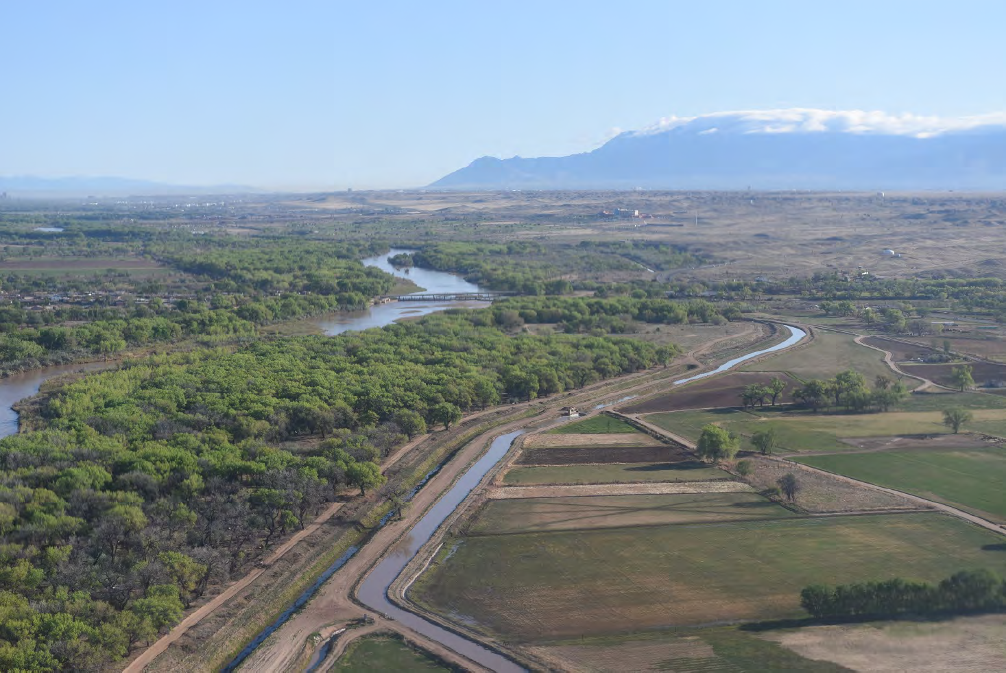
Photo Credit: Bureau of Reclamation
Aerial view of the Middle Rio Grande Valley near river mile 69.5 and San Marcial Bridge.
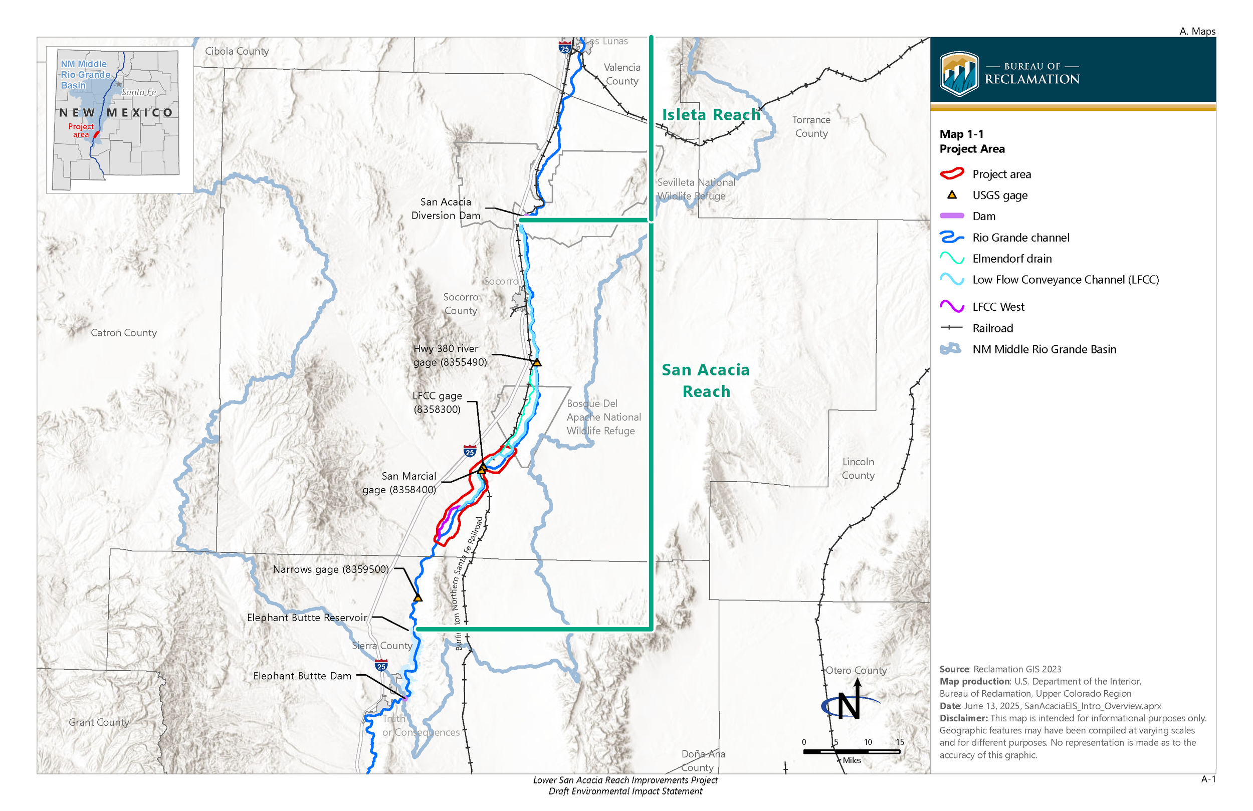
The Bureau of Reclamation (Reclamation) prepared a Draft Environmental Impact Statement (DEIS) for the Lower San Acacia Reach Improvements Project (LSARI). Reclamation is considering realigning a portion of the Rio Grande from approximately river mile (RM) 74 to RM 59.5 (project, proposed action); this area is located within the Lower San Acacia Reach. Reclamation is the project proponent. Reclamation is working with eight cooperating agencies in the preparation of the EIS including the following:
US Army Corps of Engineers
Middle Rio Grande Conservancy District
Elephant Butte Irrigation District
US Fish and Wildlife Service’s New Mexico Ecological Services Field Office and Bosque del Apache National Wildlife Refuge
Bureau of Land Management
New Mexico Interstate Stream Commission
New Mexico Department of Game and Fish
Other entities will be considered, as necessary, during the EIS process.
Reclamation is authorized to conduct work within the channel and floodplain of the Rio Grande under the Federal Flood Control Acts of 1948 and 1950 (Public Laws 858 and 516, respectively). Reclamation is also authorized to engage in planning for major rehabilitation and replacement of existing assets under the Reclamation Project Act of 1902 (32 Stat. 388) and supplementary acts; the Water Resources Development Act of 2007, Section 2031 (Public Law 110-114); the Omnibus Public Land Management Act of 2009 (Public Law 111-11), Title IX, Subtitle G; the Water Resources Planning Act of 1965, as amended (42 United States Code 1962a-2); and the Department of the Interior Manual Part 707 DM 1.
Purpose of and Need for Action
The purpose of the proposed realignment is to improve water conveyance to Elephant Butte Reservoir and downstream, maintain and enhance ecosystem health, and increase the benefit of maintenance actions by working with geomorphic trends.
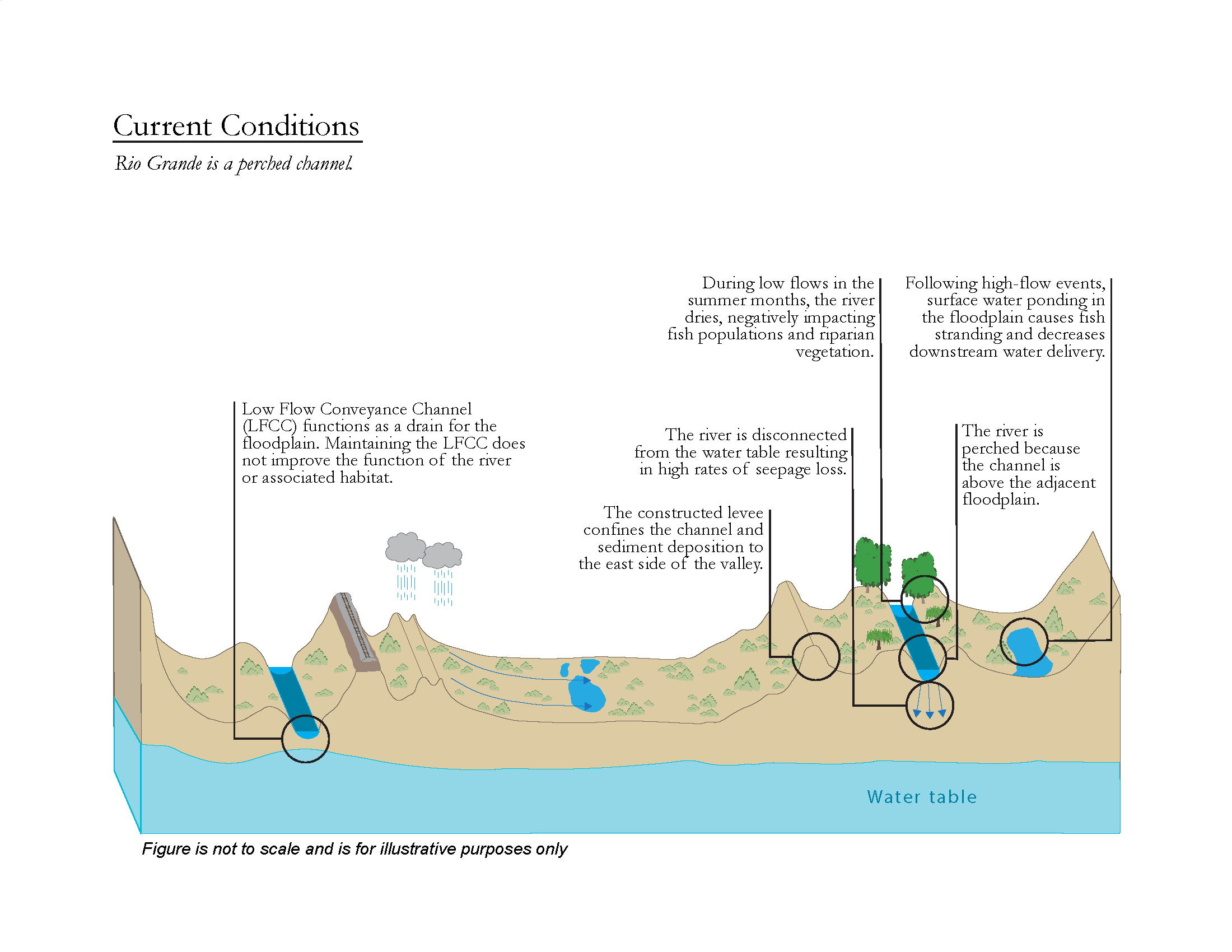
The need for the project is to address sediment imbalance, conveyance losses, maintenance costs, declining ecosystem health, and aging Low Flow Conveyance Channel (LFCC) infrastructure. Reclamation and stakeholders identified the need for the project during focused workshops and a value planning study. Most issues discussed during the workshops and value planning study identified sediment imbalance as their root cause, which can be linked to Reclamation’s management practices being at odds with geomorphic trends.
Key Issues
Channel Perching
Channel perching occurs when high sediment loads are deposited in a system with a fixed channel location and a laterally confined floodplain; it is viewed as the root cause of many of the issues within the Lower San Acacia Reach. Perching maintains the riverbed at an elevation above the water table, allowing for seepage loss and river drying. Perching increases sediment concentration in the main channel, allowing sediment plugs to form, leading to levee breeches and significant losses as water spills into low-elevation areas disconnected from the main channel. Under the action alternatives, the previous river channel perched above the floodplain would no longer convey flows.
Conveyance Losses
Several factors contribute to conveyance losses. Transpiration, water vapor released from vegetation, and evaporation. In addition, water vapor lost from open water and moist soil can significantly reduce flows. Seepage, the infiltration of surface water into the ground, also contributes to water loss. The rate of water loss due to seepage depends on the gradient to the water table and soil properties. Stranded water, which remains ponded and does not return to the river after a high-flow event, occurs when the floodplain is disconnected from the main channel. Disconnection can be the result of perching or incision. Flows from the main channel and LFCC would be consolidated into a new channel at the valley low point, increasing conveyance.
Decline in Ecosystem Health
Historically a wide and shallow river, the Rio Grande currently presents a narrow and uniform channel. Likely in response to changes in habitat conditions, the Rio Grande silvery minnow (Hybognathus amarus) was federally listed as an endangered species in 1994, the yellow-billed cuckoo (Coccyzus americanus) was federally listed as a threatened species in 2014, and the southwestern willow flycatcher (Empidonax traillii extimus) was federally listed as an endangered species in 1995. All three species and their habitat require frequent floodplain inundation to thrive. Less frequent floodplain inundation stresses native vegetation and allows invasive phreatophytes, or deep-rooted plants that obtain their water from the water table or the layer of soil just below it, to dominate riparian areas, reducing the native habitat available. Consolidating flows would increase the amount of water in the river and reduce river drying during the summer months, benefiting the Rio Grande silvery minnow and riparian vegetation.

Project Overview Map
For further information
For more information on the LSARI EIS, please contact David (Sonny) Cooper, Project Manager (bor-sha-aao-lsari@usbr.gov).
To be added to or removed from the mailing list, please contact Val Stanson (val.stanson@aecom.com).
Persons who use a telecommunications device for the deaf may call the Federal Relay Service (FedRelay) at 1-800-877-8339 TTY/ASCII to contact the above individual during normal business hours or to leave a message or question after hours. You will receive a reply during normal business hours.
For more information on the LSARI EIS, please contact David (Sonny) Cooper, Project Manager (bor-sha-aao-lsari@usbr.gov).
To be added to or removed from the mailing list, please contact Val Stanson (val.stanson@aecom.com).