
Lower San Acacia Reach Improvements Project Environmental Impact Statement
Description of Alternatives

Photo credit: Bureau of Reclamation
Description of Alternatives
Reclamation intends to realign a portion of the Rio Grande to the west of the existing channel between river mile (RM) 74 and RM 59.5. Reclamation is currently considering one no action alternative and two action alternatives.
Alternative A - No Action
Alternative A represents the continuation of current operations and maintenance (O&M); it provides a basis for comparison with the action alternatives. Under Alternative A, Reclamation would not complete a channel realignment or construct new infrastructure, and the existing channel and Low Flow Conveyance Channel (LFCC) between river mile (RM) 74 and RM 59.5 would remain as they are.

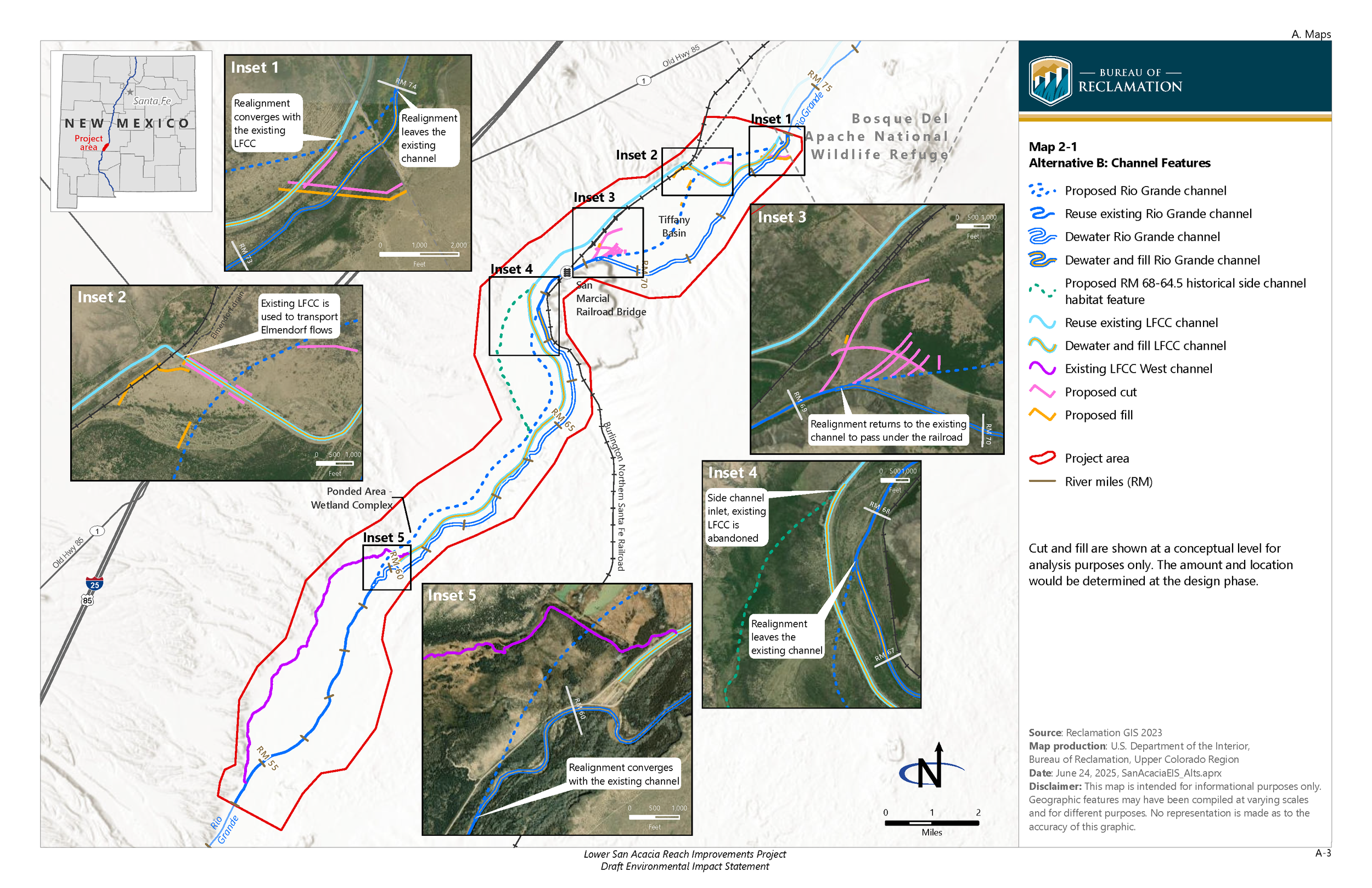
Alternative B (Preferred Alternative)
Under Alternative B, Reclamation would realign the river to the west, near RM 74 just upstream of the southern boundary of Bosque del Apache National Wildlife Refuge. The realignment would be constructed by filling a portion of the existing river channel immediately downstream of RM 74 and allowing the realigned river to flow west toward the LFCC. Reclamation would construct a berm and flow path to connect the upstream overbanking flow to the realigned river. At the intersection of the proposed realigned river with the LFCC near RM 73.3, Reclamation would fill the entire LFCC immediately downstream of the intersection. LFCC flow would enter the realigned Rio Grande channel at RM 73.3, increasing the flow in the river by 100 to 200 cubic feet per second (cfs). The realigned river would flow through the Tiffany Basin and cross the LFCC again near RM 72.5, where Reclamation would fill in the LFCC and remove the existing levees to create a floodplain. The realigned river would reconnect to the existing channel near RM 69.3 upstream of the San Marcial Railroad Bridge.
The LFCC would continue to receive irrigation return flows from the Elmendorf Drain. Reclamation would place a berm in the LFCC east of the Elmendorf culvert outlet to prevent backflows to the upstream LFCC. Water from the Elmendorf Drain would continue to enter the LFCC at approximately 35 cfs and flow downstream to the west of the railroad embankment until RM 68. Starting near RM 68, the existing LFCC would be filled, and an approximately 5,000-foot-long, 150-foot-wide channel would be excavated to allow flows from the Elmendorf Drain to leave the LFCC and enter an existing flow path and new habitat feature, which is a historical side channel along the valley’s west edge from RM 68 to 64.5. It is anticipated that providing flow through this historical side channel habitat feature would allow for periodic overbanking and additional habitat. The goal of this feature is to improve avian habitat and offset the anticipated habitat loss that would result from reducing flow frequency in the LFCC West. Flows from the Elmendorf Drain would continue through this existing flow path and reconnect to the realigned river near RM 64.5.
Downstream of the San Marcial Railroad Bridge, the realigned river would flow west starting near RM 67.7 and would cross the existing LFCC a third time, near RM 67.3. Reclamation would fill the LFCC upstream and downstream of this intersection. The realigned river would continue southwest until it intersects and flows through an existing pond complex near RM 61. Reclamation would excavate an inlet and outlet for the realigned river at the upstream and downstream edges of the pond complex.
Downstream of the pond complex, the realigned river would continue southwest toward RM 60. While the RM 60 project would be removed, water from the realigned river would periodically enter LFCC West during high-flow events (above 5,000 cfs). Reclamation would excavate the levee and an inlet channel from the floodplain to connect the realigned river with the existing channel near RM 59.5. Construction under Alternative B would occur over approximately 2 years.
Alternative C
Under Alternative C, the beginning of the river realignment would be similar to that under Alternative B, except the proposed river realignment would occur near RM 72.5, downstream of where the LFCC turns to the west across the Tiffany Basin. The realignment would be constructed by filling a portion of the existing river channel immediately downstream of RM 72.5 and allowing the realigned river to flow southwest through the Tiffany Basin. Reclamation would construct a berm and flow path to connect the upstream overbanking flow with the realigned river.
Unlike under Alternative B, under Alternative C, the LFCC would continue to carry irrigation return flows and valley drainage until RM 67.3, where the LFCC would intersect with the realigned river. There, Reclamation would fill the downstream section of the LFCC to redirect approximately 100 to 200 cfs from the LFCC to the realigned river. Under Alternative C, no flows would enter the RM 68 to 64.5 historical side channel habitat feature.
The realigned river would flow through the Tiffany Basin and reconnect to the existing channel near RM 69.3, upstream of the San Marcial Railroad Bridge. From this point, the realigned river would follow the same path downstream as described in Alternative B, including the intersection with the pond complex. Flows periodically would enter the LFCC West during high-flow events, as described in Alternative B. Construction under Alternative C would occur in under 2 years, since less material would be excavated compared with Alternative B.

For more information on the LSARI EIS, please contact David (Sonny) Cooper, Project Manager (bor-sha-aao-lsari@usbr.gov).
To be added to or removed from the mailing list, please contact Val Stanson (val.stanson@aecom.com).